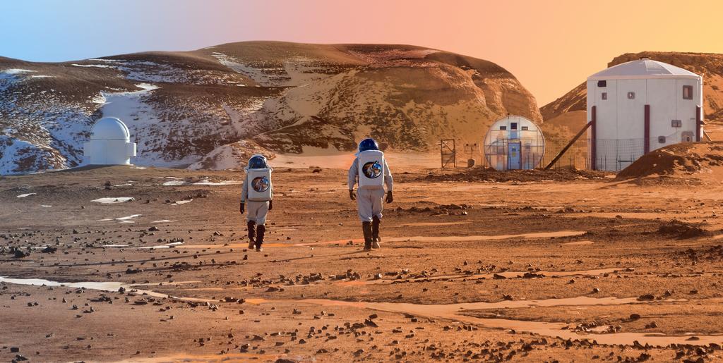
INSIGHTS into the MARS MISSION to map MARS GEOLOGICAL ACTIVITY.
Possible Mission objectives MARS INSIGHT and the CUBE satellites.
GEOLOGICAL SURVEY MISSION.

GEOLOGY of EARTH and MARS
from
Wikipedia
date 2018
November 03
The so-called Richter magnitude scale – more accurately, Richter's magnitude scale, or just Richter magnitude – for measuring the strength ("size") of earthquakes refers to the original "magnitude scale" developed by Charles F. Richter and presented in his landmark 1935 paper, and later revised and renamed the Local magnitude scale, denoted as "ML" or "ML". Because of various shortcomings of the ML scale most seismological authorities now use other scales, such as the moment magnitude scale (Mw), to report earthquake magnitudes, but much of the news media still refers to these as "Richter" magnitudes. All magnitude scales retain the logarithmic character of the original, and are scaled to have roughly comparable numeric values.
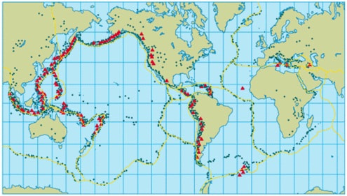
FAULT LINES indicate the zones in Earth's geology that are tectonic plates in motion that are linked together by the MOLTEN LAVA created by friction of their motion.
Possibility:
The INSIGHT mission could look for waves or vibrations of the sources of Earthquake activity and locate the INNER FAULT LINES within MARS and their motion to the surface and the temperature of them to indicate their fluidity or solidity.
from:
Wikipedia
date 2018
November 03
The Richter magnitude scale is a scale of numbers used to tell the size of earthquakes. Charles Richter developed the Richter Scale in 1935. His scale was based on the seismogram measured by a particular type of seismometer at a distance of 100 kilometres (62 mi) from the earthquake.
Earthquakes 4.5 or higher on the Richter scale can be measured by tools all over the world.
The amplitude of an earthquake that scores 3.0 is about 10 times the amplitude of one that scores 2.0. The energy that is released increases by a factor of about 32.
Possibility:
THE SCALE may indicate where any future settlements or missions should go to in reference to places with minimal or no fault line activity.
DescriptorRichter Magnitude numberDamage caused by the earthquakeFrequency of occurrence
MicroLess than 2.0Micro (very small) earthquakes, people cannot feel these.About 8,000 each day
Very minor2.0-2.9People do not feel these, but seismographs are able to detect them.About 1,000 per day
Minor3.0-3.9People often feel these, but they almost never cause damage.About 49,000 each year
Light4.0-4.9Objects inside houses are disturbed, causing noise. Things are rarely damaged.
About 6,200 each year
Moderate5.0-5.9Buildings that are not built well may be damaged. Light objects inside a house may be moved.
About 800 per year
Strong6.0-6.9Moderately powerful. May cause a lot of damage in a larger area.
About 120 per year
Major7.0-7.9Can damage things seriously over larger areas.About 18 per year
Great8.0-9.9Massive damage is caused. Heavy objects are thrown into the air and cracks appear on the ground, as well as visible shockwaves. Overhead highways may be destroyed, and buildings are toppled.About 1 per 20 years
Meteoric10.0+There are no records of anything of this size. The vibration is about the same as that of a 15 mi meteor.
Possibility:
The new Richter scale might need to be made as the reference of the EARTH'S Richer scale being 1 to 10.
While the MARS Richer would be 1/3 of it due to the facts that the Earth is 3 times bigger than MARS.
Meaning that the scale of earthquakes on Mars must be from 0.3 to 3.33
The SPACE WEATHER as the solar system in change with the effects of the SUN on the planets and the CAUSE of EARTHQUAKES in reference to their positions of the planets and WAVES similar to Earthquakes moving through space.
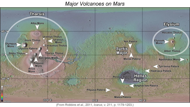
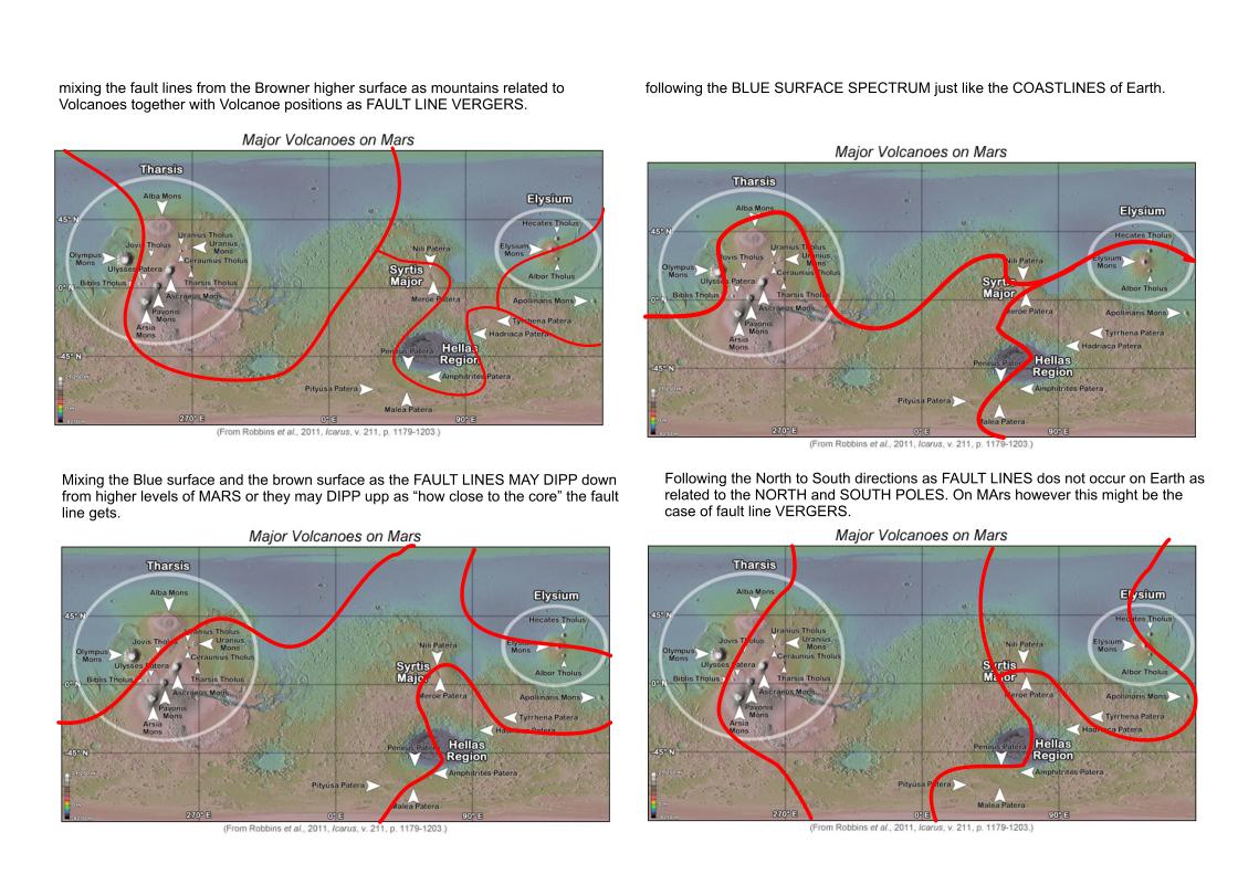
The MARS activity however is based on the positions of the Volcanoes as indicating where the MARS FAULT LINES are positioned so that by visual observation we may see the tectonic plates and their most direct route as the fault line positioning with the PLATES being in separate zones that are individual plates and how they move.
The MARS activity however is based on the positions of the Volcanoes as indicating where the MARS FAULT LINES are positioned so that by visual observation we may see the tectonic plates and their most direct route as the fault line positioning with the PLATES being in separate zones that are individual plates and how they move.
Possibility:
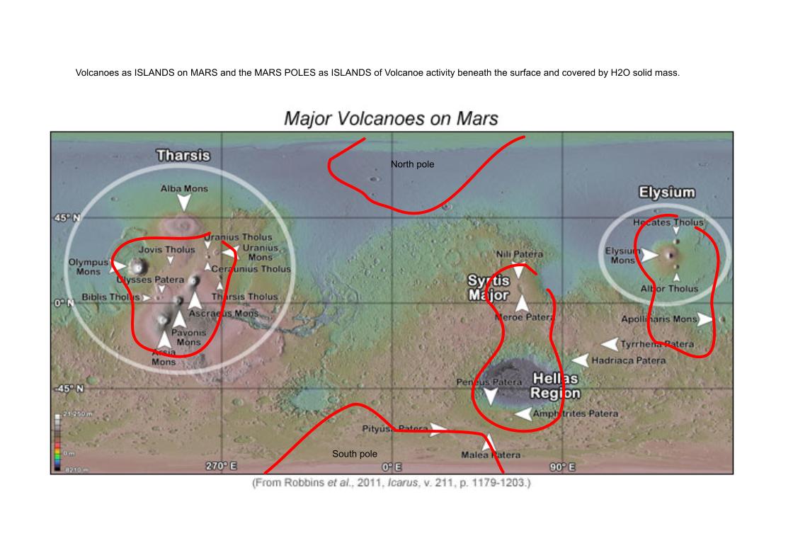
Where there is water, there are direct references to FAULT LINES on the edges with the dry land as seen on Earth. So the case being that on MARS there is only water in great amounts on the POLES might indicate that the poles become TECTONIC ISLANDS related to the other TECTONIC ISLANDS of the largest volcanoes and no dry land beneath them at any marginal height .Meaning the poles could be suspended on fluid water.
Where there is water, there are direct references to FAULT LINES on the edges with the dry land as seen on Earth. So the case being that on MARS there is only water in great amounts on the POLES might indicate that the poles become TECTONIC ISLANDS related to the other TECTONIC ISLANDS of the largest volcanoes and no dry land beneath them at any marginal height .Meaning the poles could be suspended on fluid water.
Possibility:
Other possibles of the fault lines having some way of moving between the high and low MARS surfaces=the LAVA is not heavy but made to be liter by some rock substance that could be giving it oxygen so that it FLOATS in the FAULT LINES.
This flow may be COVERED BY ROCK matter or it may be DEEPER still as in reference to "TYPE ICE BERGS" as "ROCK BERGS" that compress inwards the deeper you go.
They would create "EARTH BERG ISLANDS in motion as floating on the liter LAVA MATTER.
Possibility:
But also LAVA motion may be observed as between fault lines as= the fault lines are in the MEDIUM HEIGHT and the LAVA is at MEDIUM temperature,indicating slow LAVA motion or faster motion where LAVA flows from high to low.
Possibility:
Or as the POLAR MAGMA being pressed down by the weight of the ICE on it and the MAGMA being pressurized into the OXYGEN rich lava that gets denser or is pressed out to move along other fault lines with flow increased the closer to the poles.This flow would slow down at the Equator or it may SPEED UP at the equator due to the MARINER VALLEY EFFECT that opens up the EQUATORIAL PLANE at some depth beneath which could be DRY MAGMA or FLUID MAGMA.
Here are some INTELLIGENT GUESSES related to water and the opposites of being outside the FAULT LINES but also observing the landscape as though it were water in motion.
Possibilities:
The creation of MARS may have had some influence on the way that FAULT LINES were developed from asteroid impacts that were centered about the fault lines we observe today with MARS. Probably because the matter of the asteroids that impacted MARS from it's beginnings contained MAGNETIC LAVA with some MAGNETIC N and S orientation that separates at the POLES when it surfaces , and ATTRACTS on the West and East sides of MARS when it FLOWS BACK to the CORE by CIRCULATION ,thus keeping the whole together from the BIGGEST N or S magnetic orientation. So the INNER MAGNETIC CORE has had time to grow in temperature while the FAULT LINES keep their temperature by activity in motion are at lower temperature or the ISLANDS of VOLCANOES are equal in temperature to the INNER CORE due to SUBVENTION
.
As the LAVA related to the core and the fault lines could depend on the temperature differences of LAVA being 1/3 liter in weight than on Earth, so then the 1/3 radius of Earth may also be changed in reference to calculating all the values for the radius and MAGNETIC DIAMETERS that occur on Earth at the poles but which may be occurring at the EAST and WEST positions on MARS.
As Mars was created by the attraction of asteroids as it rotated and that these impacted MARS at a slower rate than at the formation of Earth, by about 1/3 , the effect on MARS would be that the SEPARATION of Each asteroid impact being separated by 2/3 S displacement ,meaning that the GEOLOGICAL ATTRACTION is lower as the function of distance increases.
Possibility:
The INSIGHT MISSION and the 2 CUBE SATELLITES would be doing the conversion calculations of the 1/3 size related to Earth prior to any data being released from MARS.
